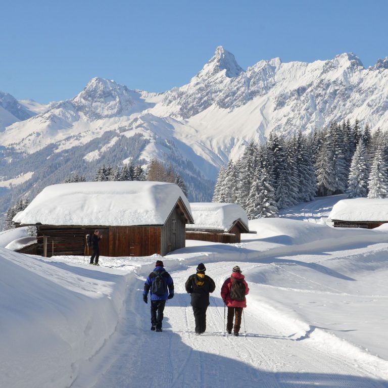
C Winter hiking trail in Schröcken (c) walser-image.com
On trails of white
Enjoy moments of peace
Official Tourism Portal Vorarlberg
Tue
Sonne-6.0°C 5.0°C
Wed
Sonne-3.0°C 9.0°C
Thu
Sonne0.0°C 12.0°C
Fri
Sonne3.0°C 10.0°C
Sat
Sonne1.0°C 7.0°C
Sun
Sonne0.0°C 4.0°C
C Winter hiking trail in Schröcken (c) walser-image.com
Enjoy moments of peace
Discover winter nature on the go
There is something extra special about finding peace while moving through winter landscapes. Countless winter hiking trails lead to scenic places.
All of Vorarlberg’s regions are composed of a well-conceived and extensive network of uniformly signposted winter hiking trails. In many places, guided hikes are also offered.
Suggestions and tips can be found here. An interactive map that details the approx. 180 winter-hiking trails shows the location of both easy strolls through nature and more challenging tours. The maps provide route information regarding the length, approx. walking time and elevation gain, as well as info on attractions, mountain restaurants and refreshments en route. Trail photos are also featured.
Fraxern village square (817m) – Sportplatz (1000m) – Alpe Maisäss (1350m). You may also…
10,3 km
03:30 h
mittel
Difficulty: | mittel |
---|---|
Distance: | 10,3 km |
Ascent: | 560 m |
Descent: | 560 m |
Duration: | 03:30 h |
Deepest point: | 819 m |
Highest point: | 1362 m |
Condition: |
|
Experience: |
|
Landscape: |
|
Fraxern village square (817m) – Sportplatz (1000m) – Alpe Maisäss (1350m). You may also depart…
Start of tourFraxern village square
End of tourAlpe Maisäß
DescriptionFraxern is a sun-kissed mountain village in Vorarlberg’s Rhine valley with breathtaking views, famed for the delicious cherries they grow there in summer, and for lovely sunshine high above the fog blanket that hangs over the valley in winter. As a hiking area, Fraxern is popular all year round.
Best seasonJAN | FEB | MAR | APR | MAY | JUN |
JUL | AUG | SEP | OCT | NOV | DEC |
Bildstein village square (665m) – Kapf (815m) – Geisbirn (822m) – Farnach Moos (880m)…
8,2 km
02:30 h
leicht
Difficulty: | leicht |
---|---|
Distance: | 8,2 km |
Ascent: | 350 m |
Descent: | 350 m |
Duration: | 02:30 h |
Deepest point: | 654 m |
Highest point: | 946 m |
Condition: |
|
Experience: |
|
Landscape: |
|
Bildstein village square (665m) – Kapf (815m) – Geisbirn (822m) – Farnach Moos (880m) –…
Start of tourBildstein village square
End of tourBildstein village square
DescriptionThe route runs on quiet access roads with hard surface. For hikers, roads are most comfortable when they are freshly cleared after snowfall, but still covered by a thin snow layer.
Best seasonJAN | FEB | MAR | APR | MAY | JUN |
JUL | AUG | SEP | OCT | NOV | DEC |
From the bus stop in Baad on the circular walk to Bärgunttal to Bärgunthütte…
4,7 km
01:45 h
leicht
Difficulty: | leicht |
---|---|
Distance: | 4,7 km |
Ascent: | 187 m |
Descent: | 187 m |
Duration: | 01:45 h |
Deepest point: | 1223 m |
Highest point: | 1404 m |
Condition: |
|
Experience: |
|
Landscape: |
|
From the bus stop in Baad on the circular walk to Bärgunttal to Bärgunthütte and…
Start of tourBaad
End of tourBaad
DescriptionIt is hard to imagine today that in the Stone Age hunters roamed the rearmost Kleinwalsertal, which even boasts a major find of stone implements and weaponry of the time. When in the late Middle Ages the Walser immigrated from the Tannberg to the Breitach valley, the Bärgunttal valley was presumedly their main access. Via Hochalp pass they were connected with the assizes in Tannberg up until 1563. It is…
Best seasonJAN | FEB | MAR | APR | MAY | JUN |
JUL | AUG | SEP | OCT | NOV | DEC |
Übersaxen, village square (899m, parking site) – St. Anna chapel (980m) – Weiherberg (1015m)…
5,8 km
02:15 h
mittel
Difficulty: | mittel |
---|---|
Distance: | 5,8 km |
Ascent: | 320 m |
Descent: | 320 m |
Duration: | 02:15 h |
Deepest point: | 898 m |
Highest point: | 1220 m |
Condition: |
|
Experience: |
|
Landscape: |
|
Übersaxen, village square (899m, parking site) – St. Anna chapel (980m) – Weiherberg (1015m) –…
Start of tourÜbersaxen
End of tourGulmalpe
DescriptionThe Rhine valley stands out for two distinct features: the vibrancy of a densely populated area and its rolling countryside with unspoilt and pristine recreational landscapes. Especially on winter days, when a thick blanket of fog covers the valley, you may feel tempted to escape high up to the mountains for the glittering white and the warming rays of sun. One such popular escape is Übersaxen, which derives its name…
Best seasonJAN | FEB | MAR | APR | MAY | JUN |
JUL | AUG | SEP | OCT | NOV | DEC |
Gaschurn, Versettlabahn valley terminal (965m) – Mountain Beach (940m) – Gortipohl (900m) – Garfreschabahn…
6,7 km
02:00 h
leicht
Difficulty: | leicht |
---|---|
Distance: | 6,7 km |
Ascent: | 42 m |
Descent: | 144 m |
Duration: | 02:00 h |
Deepest point: | 845 m |
Highest point: | 981 m |
Condition: |
|
Experience: |
|
Landscape: |
|
Gaschurn, Versettlabahn valley terminal (965m) – Mountain Beach (940m) – Gortipohl (900m) – Garfreschabahn (860m)…
Start of tourZentrum Gaschurn
End of tourSt. Gallenkirch village centre
DescriptionIn long-bygone days, more precisely between 1928 and 1953, there used to be a railroad serving the Hinteres Montafon. This narrow-gauge railway operated between Tschagguns and Partenen during the construction of the Illwerke power plant. Today, the abandoned railway line is mostly used as a road by motorists and pedestrians, and as a village-to-village hiking trail in winter.
Best seasonJAN | FEB | MAR | APR | MAY | JUN |
JUL | AUG | SEP | OCT | NOV | DEC |
Necessary cookies are absolutely necessary for the proper functioning of the website. This category only includes cookies that guarantee basic functionality and security features of the website. These cookies do not store any personal information.
These cookies are used to generate statistics and enable us to optimize the website for our visitors.