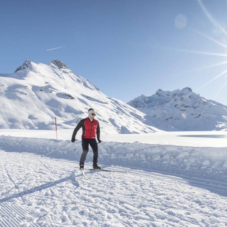
Ein Mann skatet auf der Höhenloipe auf der Silvretta Bielerhöhe, im Hintergrund sieht man den fast zugefrorenen Silvretta Stausee, die Sonne strahlt vom Himmel.

Cross-country skiing: Elevated trails in Vorarlberg

Cross-country-ski bliss at 2,000 metres

A must for all cross-country-ski fans!

  • Loipe 2000 at the Bielerhöhe in Montafon
    The highest cross-country-ski trail in Vorarlberg can be found at the Silvretta-Bielerhöhe. Here you can glide through the snow at 2,000 metres above sea level. Regardless of whether you prefer classic cross-country skiing or skating, enthusiasts of all stripes will enjoy the glittering winter landscapes of Silvretta. Vorarlberg’s highest cross-country-ski trail extends aoround the Silvretta lake. Visitors can take or a total of 22 km! Here there is something for every level of ability. Tip: Changing rooms and lockers are available at the Piz Buin mountain inn.
  • Kristberg panorama cross-country-ski trail in Montafon
    The start of this panorama trail, which is groomed and tracked daily (for classic cross-country style only, at approx. 1,400 m elevation, 11 km long), is the Kristberg cable car in Montafon. The mountain station is located directly along the cross-country-ski trail. As a service to guests, free heated changing rooms with clothes cabinets are available at the mountain station of the Kristberg cable car. There are also two waxing stations. Equipment may be rented at the Silbertal ski school or at the Kristberg panorama guest house.
  • Hochtannberg high-elevation cross-country-ski trail in Bregenzerwald
    1,600 – 1,700 metres. The ideal starting point for your high-elevation training. 4 circuits of all difficulty levels totalling approx. 17 km extend from the Hotel Jägeralpe to the Körbersee lake. The tours lead along the Hochtannberg Pass, a unique natural landscape with gentle ridges and grand mountain peaks. Cross-country skiing equipment can be rented at the sports shops (Jägeralp-Express or Salober-Jet) right on the trail.
  • Cross-border high-elevation cross-country ski trail at Hochhäderich
    This high-elevation cross-country ski trail (fee required) is beautiful and diverse. Featuring switchbacks in the heart of nature with no traffic noise, this special trail is open until Easter. With multiple tracks, the Koyental high-elevation cross-country ski trail extends through a moss-covered area in Koyental over open, sunny terrain through a protected natural area. The Hochwies cross-country ski trail crosses the border through a pristine natural landscape and ends with a short downhill descent. The Hörmoos cross-country ski trail is set upon a sunny high plateau around the Hörmoos lake (experience required).
  • Älpele cross-country ski trail in Zugertal near Lech
    The 11-km stretch begins in Lech (1,444 m elevation) and extends along the Lech river through the exciting Zugertal valley to the Älpele inn (open, serves food & drink) and onward to the Alpe Tannläger.
  • Flexen Pass high-elevation cross-country ski trail
    Comfortable tour for beginners on expertly prepared and sunny trail over a high plateau to the Flexen Pass (1,733 m) and back.
  • Rona panorama cross-country ski trail with view into 5 valleys
    Three cross-country ski trails at an elevation of 1,250 metres on the Tschengla high plateau in the Brandnertal valley. This trail leads skiers through meadows and forest to the stone circles of the Alpe Rona.

Cross-country skiing: Elevated trails in Vorarlberg

Online Map

    • Langlaufen_Galtür_2024_©TVB-Paznaun-Ischgl(24).jpg

      No. 1: Cross-country ski trail Bielerhöhe-Galtür

      From the Silvretta-Bielerhöhe, the Vermunt Route 2 takes you down along Lake Silvretta toward…

      • 7.89 km

      • 2.2 h

      • Unbekannt

      Distance: 7.89 km
      Ascent: 237 m
      Descent: 237 m
      Duration: 2.2 h
      Deepest point: 1807 m
      Highest point: 2036 m
      Condition:

      Experience:

      Landscape:

      No. 1: Cross-country ski trail Bielerhöhe-Galtür

      From the Silvretta-Bielerhöhe, the Vermunt Route 2 takes you down along Lake Silvretta toward Wirl/Galtür…

      Start of tour

      Berggasthof Piz Buin, Silvretta-Bielerhöhe

      End of tour

      Berggasthof Piz Buin, Silvretta-Bielerhöhe

      Best season
      JAN FEB MAR APR MAY JUN
      JUL AUG SEP OCT NOV DEC
      All route info
    • Langlaufen_Galtür_2024_©TVB-Paznaun-Ischgl(24).jpg

      No. 2: Dam Trail Silvretta-Bielerhöhe

      From Silvretta-Bielerhöhe, the Dammloipe trail takes you along the dam of Lake Silvretta and…

      • 1.98 km

      • 0.6 h

      • Unbekannt

      Distance: 1.98 km
      Ascent: 82 m
      Descent: 82 m
      Duration: 0.6 h
      Deepest point: 2003 m
      Highest point: 2077 m
      Condition:

      Experience:

      Landscape:

      No. 2: Dam Trail Silvretta-Bielerhöhe

      From Silvretta-Bielerhöhe, the Dammloipe trail takes you along the dam of Lake Silvretta and back…

      Start of tour

      Berggasthof Piz Buin, Silvretta-Bielerhöhe

      End of tour

      Berggasthof Piz Buin, Silvretta-Bielerhöhe

      Best season
      JAN FEB MAR APR MAY JUN
      JUL AUG SEP OCT NOV DEC
      All route info
    • Langlaufen_Galtür_2024_©TVB-Paznaun-Ischgl(24).jpg

      No. 3: Silvretta high altitude trail, small

      On the Silvretta-Bielerhöhe, the short high-altitude cross-country trail takes you on a brief training…

      • 0.56 km

      • 0.2 h

      • Unbekannt

      Distance: 0.56 km
      Ascent: 13 m
      Descent: 13 m
      Duration: 0.2 h
      Deepest point: 2023 m
      Highest point: 2037 m
      Condition:

      Experience:

      Landscape:

      No. 3: Silvretta high altitude trail, small

      On the Silvretta-Bielerhöhe, the short high-altitude cross-country trail takes you on a brief training loop…

      Best season
      JAN FEB MAR APR MAY JUN
      JUL AUG SEP OCT NOV DEC
      All route info
    • Langlaufen_Galtür_2024_©TVB-Paznaun-Ischgl(24).jpg

      No. 4: Silvretta high trail, medium

      The Silvretta Intermediate Cross-Country Trail takes you on a roughly two-kilometer loop through the…

      • 2.01 km

      • 0.7 h

      • Unbekannt

      Distance: 2.01 km
      Ascent: 53 m
      Descent: 53 m
      Duration: 0.7 h
      Deepest point: 2008 m
      Highest point: 2056 m
      Condition:

      Experience:

      Landscape:

      No. 4: Silvretta high trail, medium

      The Silvretta Intermediate Cross-Country Trail takes you on a roughly two-kilometer loop through the high-alpine…

      Start of tour

      Berggasthof & Hotel Piz Buin, Silvretta-Bielerhöhe

      End of tour

      Berggasthof & Hotel Piz Buin, Silvretta-Bielerhöhe

      Best season
      JAN FEB MAR APR MAY JUN
      JUL AUG SEP OCT NOV DEC
      All route info
    • Langlaufen_Galtür_2024_©TVB-Paznaun-Ischgl(24).jpg

      No. 5: Silvretta high trail (large)

      Berggasthof Piz Buin - Barbara Chapel - towards Vermuntsee - Silvretta House - Berggasthof…

      • 4.02 km

      • 1.1 h

      • Unbekannt

      Distance: 4.02 km
      Ascent: 85 m
      Descent: 84 m
      Duration: 1.1 h
      Deepest point: 2009 m
      Highest point: 2056 m
      Condition:

      Experience:

      Landscape:

      No. 5: Silvretta high trail (large)

      Berggasthof Piz Buin - Barbara Chapel - towards Vermuntsee - Silvretta House - Berggasthof Piz…

      Start of tour

      Berggasthof Piz Buin, Silvretta-Bielerhöhe

      End of tour

      Berggasthof Piz Buin, Silvretta-Bielerhöhe

      Description

      The Silvretta-Bielerhöhe offers trails for every taste. Cross-country skiing strengthens the cardiovascular system and shapes the figure. Freshly groomed trails, a fantastic winter panorama, and unique views of the surrounding mountain world.

      Best season
      JAN FEB MAR APR MAY JUN
      JUL AUG SEP OCT NOV DEC
      All route info
    • Langlaufen_Galtür_2024_©TVB-Paznaun-Ischgl(24).jpg

      No. 6: Madlenerhaus Cross-Country Trail, moderate

      The middle Madlenerhaus cross-country trail takes you on a loop through the high-alpine winter…

      • 1.24 km

      • 0.3 h

      • Unbekannt

      Distance: 1.24 km
      Ascent: 2 m
      Descent: 2 m
      Duration: 0.3 h
      Deepest point: 1977 m
      Highest point: 1990 m
      Condition:

      Landscape:

      No. 6: Madlenerhaus Cross-Country Trail, moderate

      The middle Madlenerhaus cross-country trail takes you on a loop through the high-alpine winter landscape…

      Best season
      JAN FEB MAR APR MAY JUN
      JUL AUG SEP OCT NOV DEC
      All route info
    • Langlaufen_Galtür_2024_©TVB-Paznaun-Ischgl(57).jpg

      No. 7: Madlenerhaus Trail, short

      The short Madlenerhaus cross-country trail takes you on a brief practice loop through the…

      • 0.95 km

      • 0.3 h

      • Unbekannt

      Distance: 0.95 km
      Ascent: 20 m
      Descent: 20 m
      Duration: 0.3 h
      Deepest point: 1972 m
      Highest point: 1992 m
      Condition:

      Landscape:

      No. 7: Madlenerhaus Trail, short

      The short Madlenerhaus cross-country trail takes you on a brief practice loop through the high-alpine…

      Best season
      JAN FEB MAR APR MAY JUN
      JUL AUG SEP OCT NOV DEC
      All route info
    • Langlaufen_Galtür_2024_©TVB-Paznaun-Ischgl(57).jpg

      No. 8: Madlenerhaus Cross-Country Trail, Long

      The long Madlenerhaus cross-country trail takes you on an extended loop through the high-alpine…

      • 1.97 km

      • 0.5 h

      • Unbekannt

      Distance: 1.97 km
      Ascent: 29 m
      Descent: 29 m
      Duration: 0.5 h
      Deepest point: 1972 m
      Highest point: 1992 m
      Condition:

      Landscape:

      No. 8: Madlenerhaus Cross-Country Trail, Long

      The long Madlenerhaus cross-country trail takes you on an extended loop through the high-alpine winter…

      Best season
      JAN FEB MAR APR MAY JUN
      JUL AUG SEP OCT NOV DEC
      All route info
    • Schleife beim Wildried

      Nr. 26: Panoramaloipe Kristberg (klassisch)

      The panoramic cross-country trail on the Kristberg combines a varied loop at various elevations…

      • 11 km

      • 1.5 h

      • Unbekannt

      Distance: 11 km
      Ascent: 181 m
      Descent: 181 m
      Duration: 1.5 h
      Deepest point: 1443 m
      Highest point: 1566 m
      Condition:

      Experience:

      Landscape:

      Nr. 26: Panoramaloipe Kristberg (klassisch)

      The panoramic cross-country trail on the Kristberg combines a varied loop at various elevations with…

      Start of tour

      Bergstation Kristbergbahn

      End of tour

      Bergstation Kristbergbahn

      Best season
      JAN FEB MAR APR MAY JUN
      JUL AUG SEP OCT NOV DEC
      All route info
    • Bestens präparierte Langlaufloipe in Damüls

      Stofel high-altitude cross-country ski trail | Damüls

      Style: Classic / Skating

      • 2.69 km

      • 1 h

      • Unbekannt

      Distance: 2.69 km
      Ascent: 93 m
      Descent: 93 m
      Duration: 1 h
      Deepest point: 1610 m
      Highest point: 1703 m
      Condition:

      Experience:

      Landscape:

      Stofel high-altitude cross-country ski trail | Damüls

      Style: Classic / Skating

      Start of tour

      Guesthouse Zimba

      End of tour

      Guesthouse Zimba

      Description

      This cross-country skiing circuit offers fabulous views in a beautiful mountain landscape. It starts at the Zimba Guesthouse and leads in a particularly beautiful circuit over the Stofel plateau.

      Changing facilities: There are no changing facilities on site.

      Current status: You can find this in the daily updated trail report.

      Best season
      JAN FEB MAR APR MAY JUN
      JUL AUG SEP OCT NOV DEC
      All route info
    • Loipe am Hochhäderich

      Riefensberg | Hörmoos Trail

      The cross-border high-altitude cross-country ski trail, located at an elevation of 1,200 to 1,300…

      • 8.21 km

      • 1.8 h

      • schwer

      Difficulty: schwer
      Distance: 8.21 km
      Ascent: 107 m
      Descent: 107 m
      Duration: 1.8 h
      Deepest point: 1198 m
      Highest point: 1289 m
      Condition:

      Experience:

      Landscape:

      Riefensberg | Hörmoos Trail

      The cross-border high-altitude cross-country ski trail, located at an elevation of 1,200 to 1,300 meters…

      Description

      The moderately difficult Hörmoos cross-country trail leads through the sunny high plateau at Hochhäderich.

      After a climb near the Alpengasthof Hochwies, you reach the sunny plateau and Lake Hörmoos. Experienced skaters using the skating technique can take a detour to the Falkenhütte.

      Note: The trail is groomed only when snow conditions permit.

      Best season
      JAN FEB MAR APR MAY JUN
      JUL AUG SEP OCT NOV DEC
      All route info
    • Langlaluf-Warth-Schröcken(c).jpg

      Warth-Schröcken | Around lake Kalbelesee

      • 1.75 km

      • 0.5 h

      • leicht

      Difficulty: leicht
      Distance: 1.75 km
      Ascent: 6 m
      Descent: 6 m
      Duration: 0.5 h
      Deepest point: 1653 m
      Highest point: 1659 m
      Condition:

      Experience:

      Landscape:

      Warth-Schröcken | Around lake Kalbelesee

      Best season
      JAN FEB MAR APR MAY JUN
      JUL AUG SEP OCT NOV DEC
      All route info
    • Winterwandern

      Warth | Cross-country circuit Falkenkopf/Körbersee

      Length: 5,7 km | Category: Classical and skating | Difficulty: Heavy | Starting point:…

      • 5.69 km

      • 1.3 h

      • schwer

      Difficulty: schwer
      Distance: 5.69 km
      Ascent: 185 m
      Descent: 185 m
      Duration: 1.3 h
      Deepest point: 1653 m
      Highest point: 1745 m
      Condition:

      Experience:

      Landscape:

      Warth | Cross-country circuit Falkenkopf/Körbersee

      Length: 5,7 km | Category: Classical and skating | Difficulty: Heavy | Starting point: Salober…

      Start of tour

      Hochtannbergpass

      End of tour

      Hochtannbergpass

      Best season
      JAN FEB MAR APR MAY JUN
      JUL AUG SEP OCT NOV DEC
      All route info
    • Winterwandern

      Warth | Cross-country circuit Kalbelesee

      Length: 1,5 km | Category: Classic and Skating | Difficulty: Easy | Starting point:…

      • 1.46 km

      • 0.3 h

      • leicht

      Difficulty: leicht
      Distance: 1.46 km
      Ascent: 9 m
      Descent: 9 m
      Duration: 0.3 h
      Deepest point: 1653 m
      Highest point: 1662 m
      Condition:

      Experience:

      Landscape:

      Warth | Cross-country circuit Kalbelesee

      Length: 1,5 km | Category: Classic and Skating | Difficulty: Easy | Starting point: Salober…

      Start of tour

      Hochtannbergpass

      End of tour

      Hochtannbergpass

      Best season
      JAN FEB MAR APR MAY JUN
      JUL AUG SEP OCT NOV DEC
      All route info
    • Simmel

      Warth | Cross-country circuit Jägeralpe

      Length: 1 km | Category: Classic and Skating | Difficulty: Easy | Entry: Hotel…

      • 1.02 km

      • 0.2 h

      • leicht

      Difficulty: leicht
      Distance: 1.02 km
      Ascent: 12 m
      Descent: 12 m
      Duration: 0.2 h
      Deepest point: 1591 m
      Highest point: 1603 m
      Condition:

      Experience:

      Landscape:

      Warth | Cross-country circuit Jägeralpe

      Length: 1 km | Category: Classic and Skating | Difficulty: Easy | Entry: Hotel Jägeralpe

      Start of tour

      Hotel Jägeralpe

      End of tour

      Hotel Jägeralpe

      Best season
      JAN FEB MAR APR MAY JUN
      JUL AUG SEP OCT NOV DEC
      All route info
    • Simmel

      Warth | Cross-country circuit Simmel

      Length: 3,3 km | Category: Classical and skating | Difficulty: Medium | Entry: Hotel…

      • 3.3 km

      • 0.5 h

      • mittel

      Difficulty: mittel
      Distance: 3.3 km
      Ascent: 86 m
      Descent: 86 m
      Duration: 0.5 h
      Deepest point: 1591 m
      Highest point: 1675 m
      Condition:

      Experience:

      Landscape:

      Warth | Cross-country circuit Simmel

      Length: 3,3 km | Category: Classical and skating | Difficulty: Medium | Entry: Hotel Jägeralpe,…

      Start of tour

      Hotel Jägeralpe, Hotel Adler, Salober-Talstation

      End of tour

      Hotel Jägeralpe, Hotel Adler, Salober-Talstation

      Best season
      JAN FEB MAR APR MAY JUN
      JUL AUG SEP OCT NOV DEC
      All route info
    • Hochmoor Loipe Hochhäderich

      Riefensberg | Hochmoor Loipe Hochhäderich

      Schöne Loipe auf dem Hochplateau des Hochhäderichs. Geeignet für Anfänger.

      • 1.72 km

      • 0.5 h

      • leicht

      Difficulty: leicht
      Distance: 1.72 km
      Ascent: 7 m
      Descent: 7 m
      Duration: 0.5 h
      Deepest point: 1214 m
      Highest point: 1221 m
      Condition:

      Experience:

      Landscape:

      Riefensberg | Hochmoor Loipe Hochhäderich

      Schöne Loipe auf dem Hochplateau des Hochhäderichs. Geeignet für Anfänger.

      Best season
      JAN FEB MAR APR MAY JUN
      JUL AUG SEP OCT NOV DEC
      All route info
    • Tolle Langlaufloipen am Hochhäderich

      Riefensberg | Hädrich Loipe Hochhäderich

      Mittelschwere Loipe auf dem Hochplateau des Hochhäderichs, wo Sie den Winter von seiner schönsten…

      • 2.94 km

      • 0.8 h

      • mittel

      Difficulty: mittel
      Distance: 2.94 km
      Ascent: 36 m
      Descent: 36 m
      Duration: 0.8 h
      Deepest point: 1198 m
      Highest point: 1227 m
      Condition:

      Experience:

      Landscape:

      Riefensberg | Hädrich Loipe Hochhäderich

      Mittelschwere Loipe auf dem Hochplateau des Hochhäderichs, wo Sie den Winter von seiner schönsten Seite…

      Best season
      JAN FEB MAR APR MAY JUN
      JUL AUG SEP OCT NOV DEC
      All route info
    • Langlaufen im Zugertal

      Zug – Älpele – Spullerwald – Zug

      The cross-country skiing trail leads from Zug through the beautiful natural jewel of the…

      • 6.64 km

      • 1.3 h

      • schwer

      Difficulty: schwer
      Distance: 6.64 km
      Ascent: 163 m
      Descent: 127 m
      Duration: 1.3 h
      Deepest point: 1488 m
      Highest point: 1608 m
      Condition:

      Experience:

      Landscape:

      Zug – Älpele – Spullerwald – Zug

      The cross-country skiing trail leads from Zug through the beautiful natural jewel of the Zug…

      Start of tour

      Zug

      End of tour

      Zug

      Description

      You can start your cross-country tour directly in Lech at the bridge at the cross-country starting point and walk along the Lech River to Zug. Alternatively, you can take the blue local bus to Zug and get on the cross-country trail from the terminus. Up to the Älpele Inn it goes evenly up to slightly uphill. At Älpele Inn you can take a break and get some refreshments. Then take…

      Best season
      JAN FEB MAR APR MAY JUN
      JUL AUG SEP OCT NOV DEC
      All route info
    • Langlaufen im Winter ins Zugertal

      Cross country skiing through the Zuger Valley

      The cross-country skiing tour leads through the idyllic Tannlägeralpe and is popular with those…

      • 10.4 km

      • 2.8 h

      • schwer

      Difficulty: schwer
      Distance: 10.4 km
      Ascent: 244 m
      Descent: 119 m
      Duration: 2.8 h
      Deepest point: 1486 m
      Highest point: 1666 m
      Condition:

      Experience:

      Landscape:

      Cross country skiing through the Zuger Valley

      The cross-country skiing tour leads through the idyllic Tannlägeralpe and is popular with those seeking…

      Start of tour

      District Zug

      End of tour

      District Zug

      Description

      The cross-country skiing tour starts below the Zug church, directly on the Lech at the Zug mountain railway station. On the banks of the Lech, the route leads to Älpele inn. Here, one can decide whether one takes a short break or continues following the cross-country trail to the Tannlägeralpe. Partly, the track is hilly but to a large extent a dream come true for every cross-country skier. The trail…

      Best season
      JAN FEB MAR APR MAY JUN
      JUL AUG SEP OCT NOV DEC
      All route info
    • Langlaufen nach Zug

      Lech – Zugertal

      The beautiful cross-country ski run starts in Lech and leads along the banks of…

      • 2.8 km

      • 0.7 h

      • leicht

      Difficulty: leicht
      Distance: 2.8 km
      Ascent: 49 m
      Duration: 0.7 h
      Deepest point: 1440 m
      Highest point: 1490 m
      Condition:

      Experience:

      Landscape:

      Lech – Zugertal

      The beautiful cross-country ski run starts in Lech and leads along the banks of the…

      Start of tour

      Rüfiplatz

      End of tour

      Zug

      Description

      This fantastic cross-country trail, which starts directly in the centre of Lech at the covered wooden bridge, leads along the Lech directly to Zug. Even beginners will feel at home on this perfectly prepared route. The cross-country ski run has a few gradients and leads directly to Zug, past the fishpond. Experienced and ambitious skiers can continue the route to the Älpele Inn and enjoy a well-earned break with culinary…

      Best season
      JAN FEB MAR APR MAY JUN
      JUL AUG SEP OCT NOV DEC
      All route info
    • Langlaufen in Lech Zürs

      Zürs – Flexenpass – Zürs

      The cross-country skiing route is suitable for moderately advanced cross-country skiers and winter hikers.…

      • 2.19 km

      • 0.7 h

      • mittel

      Difficulty: mittel
      Distance: 2.19 km
      Ascent: 55 m
      Descent: 55 m
      Duration: 0.7 h
      Deepest point: 1715 m
      Highest point: 1773 m
      Condition:

      Experience:

      Landscape:

      Zürs – Flexenpass – Zürs

      The cross-country skiing route is suitable for moderately advanced cross-country skiers and winter hikers. The…

      Start of tour

      Zürs am Arlberg

      End of tour

      Zürs am Arlberg

      Description

      The somewhat challenging route Zürs – Flexenpass – Zürs is ideal for advanced cross-country skiers and winter hikers. Starting from Trittkopfbahn 1, follow the well-prepared cross-country trail and winter hiking trail south towards Flexenpass. Here you can either take a break in the rustic Flexenhäusl or follow the route further south. After the path makes a generous loop, the hilly route leads back to Zürs.

      Best season
      JAN FEB MAR APR MAY JUN
      JUL AUG SEP OCT NOV DEC
      All route info
    • Unterwegs auf der Olympia-Loipe

      Cross-country ski trail “Olympia” | Bürserberg

      Style: Classic / Skating on 80 % of the trail

      • 4.37 km

      • 1 h

      • Unbekannt

      Distance: 4.37 km
      Ascent: 36 m
      Descent: 36 m
      Duration: 1 h
      Deepest point: 1221 m
      Highest point: 1251 m
      Condition:

      Experience:

      Landscape:

      Cross-country ski trail “Olympia” | Bürserberg

      Style: Classic / Skating on 80 % of the trail

      Start of tour

      Car park Tschengla, Bürserberg

      End of tour

      Car park Tschengla, Bürserberg

      Description

      Discover the cross-country skiing paradise on the Tschengla high plateau with the generously designed Olympic cross-country trail. This circuit was newly created as part of the EYOF 2015, the European Youth Olympic Festival, which was held jointly by the countries of Vorarlberg and Liechtenstein in January 2015.

      From the Tschengla hikers’ car park, a short walk uphill to the start of the Olympic cross-country ski trail. The circular route leads…

      Best season
      JAN FEB MAR APR MAY JUN
      JUL AUG SEP OCT NOV DEC
      All route info

Also interesting: